No Image Lot 218 London. Large Map of Yates Estate Walworth. 50 inches x 78 inches. Made of 78 rectangles linen 218London. Large Map of Yates Estate Walworth. 50 inches x 78 inches. Made of 78 rectangles linen Spicers Auctioneers Ltd London. Large Map of Yates Estate Walworth. 50 inches x 78 inches. Made of 78 rectangles linen backed. Some minor red inking. ND, NP. (c. 1930); W... Add to watchlist Live
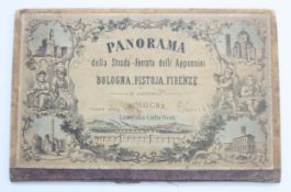
No Image Lot 536 A late 19th century Panorama map of Bologna, Pistoja and Firenze railway, retailed by Edward Goodban 536A late 19th century Panorama map of Bologna, Pistoja and Firenze railway, retailed by Edward Goodban Spicers Auctioneers Ltd A late 19th century Panorama map of Bologna, Pistoja and Firenze railway, retailed by Edward Goodban in English stationery, c.1870. Add to watchlist Live
No Image Lot 4700 END OF SALE, THANK YOU FOR YOUR BIDDING. OUR NEXT SALE IS ON THE WEDNESDAY 1ST AND THURSDAY 2ND 4700END OF SALE, THANK YOU FOR YOUR BIDDING. OUR NEXT SALE IS ON THE WEDNESDAY 1ST AND THURSDAY 2ND Ashley Waller Auctioneers END OF SALE, THANK YOU FOR YOUR BIDDING. OUR NEXT SALE IS ON THE WEDNESDAY 1ST AND THURSDAY 2ND OCTOBER Add to watchlist Live
No Image Lot 3920 A FRAMED VINTAGE MAP OF CHESTER AND THE LLANGOLLEN CANAL 3920A FRAMED VINTAGE MAP OF CHESTER AND THE LLANGOLLEN CANAL Ashley Waller Auctioneers A FRAMED VINTAGE MAP OF CHESTER AND THE LLANGOLLEN CANAL Add to watchlist Live
No Image Lot 3500 END OF SALE, THANK YOU FOR YOUR BIDDING. OUR NEXT SALE IS ON THE WEDNESDAY 29TH AND THURSDAY 30TH 3500END OF SALE, THANK YOU FOR YOUR BIDDING. OUR NEXT SALE IS ON THE WEDNESDAY 29TH AND THURSDAY 30TH Ashley Waller Auctioneers END OF SALE, THANK YOU FOR YOUR BIDDING. OUR NEXT SALE IS ON THE WEDNESDAY 29TH AND THURSDAY 30TH OCTOBER Add to watchlist Live
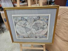
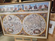
No Image Lot 569 Large Early World Map "Nova Totivs Terrarom Sive Novi Orbis Tabvla" A Striking Seventeenth-Century 569Large Early World Map "Nova Totivs Terrarom Sive Novi Orbis Tabvla" A Striking Seventeenth-Century Pro Auction Limited Large Early World Map "Nova Totivs Terrarom Sive Novi Orbis Tabvla" A Striking Seventeenth-Century Wall Map Of The World By Cornelis Danckerts Gl... Add to watchlist Live
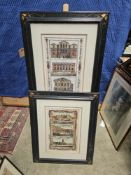
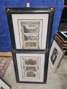
No Image Lot 630 Framed Print View Of The Guildhall Of London View Of Grocers Hall In The Poultry View Of 630Framed Print View Of The Guildhall Of London View Of Grocers Hall In The Poultry View Of Pro Auction Limited Framed Print View Of The Guildhall Of London View Of Grocers Hall In The Poultry View Of Goldsmiths Hall, Foster Lane. Published By Alexander Ho... Add to watchlist Live
No Image Lot 645 A Set Of 2 X Prints 'View Of The Tower Of London View Of The Custom House, London View Of The 645A Set Of 2 X Prints 'View Of The Tower Of London View Of The Custom House, London View Of The Pro Auction Limited A Set Of 2 X Prints 'View Of The Tower Of London View Of The Custom House, London View Of The Royal Exchange, London'. Published By Alexander Hogg... Add to watchlist Live
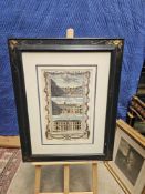
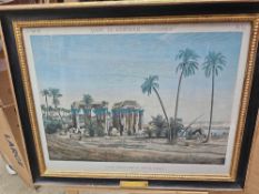
No Image Lot 560 Vue Du Temple Prise À l'Ouest" (View Of The Temple Taken From The West) After Lorieux And Berthault, 560Vue Du Temple Prise À l'Ouest" (View Of The Temple Taken From The West) After Lorieux And Berthault, Pro Auction Limited Vue Du Temple Prise À l'Ouest" (View Of The Temple Taken From The West) After Lorieux And Berthault, Pierre-Gabriel Berthault (1776-1859) Glazed A... Add to watchlist Live
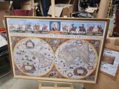
No Image Lot 561 A New And Accurate Map Of The World By John Speed, A Renowned English Cartographer Created In 1626 561A New And Accurate Map Of The World By John Speed, A Renowned English Cartographer Created In 1626 Pro Auction Limited A New And Accurate Map Of The World By John Speed, A Renowned English Cartographer Created In 1626 Or 1651 Glazed And Framed Print 74 X 62cm Add to watchlist Live
No Image Lot 638 A Set Of 2 Prints The Sessions House, Clerkenwell Green, London. Antique Engraved Print 1817 T. 638A Set Of 2 Prints The Sessions House, Clerkenwell Green, London. Antique Engraved Print 1817 T. Pro Auction Limited A Set Of 2 Prints The Sessions House, Clerkenwell Green, London. Antique Engraved Print 1817 T. Higham. Provenance: "Walks Through London, Includi... Add to watchlist Live
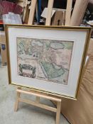
No Image Lot 562 A Map Of The Middle East From 1570. In The Top Left Of The Map Italy And Austria Are Shown, In The 562A Map Of The Middle East From 1570. In The Top Left Of The Map Italy And Austria Are Shown, In The Pro Auction Limited A Map Of The Middle East From 1570. In The Top Left Of The Map Italy And Austria Are Shown, In The Bottom Right Africa, And In The Centre Arabia. ... Add to watchlist Live
No Image Lot 563 Large Early World Map "Nova Totivs Terrarom Sive Novi Orbis Tabvla" A Striking Seventeenth-Century 563Large Early World Map "Nova Totivs Terrarom Sive Novi Orbis Tabvla" A Striking Seventeenth-Century Pro Auction Limited Large Early World Map "Nova Totivs Terrarom Sive Novi Orbis Tabvla" A Striking Seventeenth-Century Wall Map Of The World By Cornelis Danckerts Gl... Add to watchlist Live